As the availability and volume of data to help us understand what is happening or will happen in an agricultural field or orchard continues to grow exponentially, the challenge we now face is how to collect, synthesize and use this data.
 How Curating Weather And Soil Data Can Produce Actionable Environmental Intelligence

Rob Hale | Iteris
As the availability and volume of data to help us understand what is happening or will happen in an agricultural field or orchard continues to grow exponentially, the challenge we now face is how to collect, synthesize and use this data to provide simple and actionable understandings and recommendations for a user.
It is well understood that the environment has a significant impact on agricultural production. Not only does the amount of sunshine and water a crop receives directly affect that crop’s eventual yield, but environmental factors also influence the effectiveness of products that are applied to the crop. An understanding of the environment aids growers in management of critical resources, including water. It also allows agribusinesses to improve product development and better position their products after they are launched into the market.
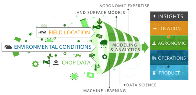
As an example, effective irrigation scheduling solutions require environmental data about the soil type and textures in the field, organic matter present in the soil, and topography, as well as historical, current, and forecasted weather variables. Aggregating data from multiple, disparate sources is challenging, and accurate recommendations also require that the data are of good quality. Once the appropriate data have been aggregated and quality assured, the physical processes that bring these data together must be applied.
An Irrigation Example
Land surface modeling can be used to integrate these weather, soil and crop variables into meaningful products that allow a user to understand the availability and movement of water within the soil and crop. ClearAg’s Land Surface Models (LSM), for example, are specifically designed to support agricultural applications, taking into account the crop type being produced and the relevant soil depths where that crop’s roots are taking up water. After all, a lettuce crop and an orange grove have vastly different water needs and root depths.
This agriculturally focused LSM can then be used to generate precise irrigation recommendations without the need for expensive in-field sensors. The collection and curation of all necessary input data from various state-of-the-science sources is done for the user. The LSM is then run specifically for the crop – and the crop’s correct timing of growth stages – to provide a tailored output. For the purpose of irrigation planning, that output is presented in simple, easy-to-understand recommendations of when to irrigate and how much, such that water use efficiency is optimized. Additional supporting data is also charted for the user to see.
Extracting Insights from the Data
The concept of distilling complex data into easy-to-understand insights or recommendations has value far beyond just irrigation scheduling. Perhaps you have a goal of understanding the risk of yield loss due to stress during the grain fill period of a cereal crop, or the risk of adverse conditions at emergence that might impact stand establishment. Or maybe you could make improved product use recommendations to your customers if you knew the risk of a particular disease to develop. Maybe you need to know which fields to send equipment to for tillage, planting, harvest, or other operations. Perhaps your research and development or product management team wants to understand whether the conditions in one testing season are representative of average conditions in an area as they evaluate a product for launch. To support such needs, at Iteris, for example, we apply an index approach to improve decision making using environmental insights.
Like the irrigation example, understanding the environmental impact on these kinds of questions requires analysis of multiple variables from different sources, as well as knowledge of the field, the crop and its growth stage. ClearAg Indices can provide you with a 1 to 100 score that quantifies the environment’s influence surrounding critical decisions for a grower or agribusiness, whether on a single field or across a set of fields or testing locations.

With all this in mind, ask yourself in what ways concise, actionable environmental insights could help support your decision making? And don’t hesitate to contact the ClearAg team to discuss how to optimize your yields.
Editors Recommendation "Automation and Sensors in Hybrid Greenhouses"
The content & opinions in this article are the author’s and do not necessarily represent the views of AgriTechTomorrow
Comments (0)
This post does not have any comments. Be the first to leave a comment below.
Featured Product


